|
|
 |
|
|
Back to main Tropical Weather page
| HILARY 2005 | Forecast
Advisories | Discussion | Wind
Probabilities | Public
Advisories | UTC | Status | Basin | Lon | Lat | Speed
(Kts) | Direction | Central
Pressure | Sustained
Winds (Kts) | Wind
Gusts (Kts) | IR Imagery |
| Latest | Latest | None | None | 2100 Thu
Aug 25, 2005 |
Depression | EP | 121.2W | 24.5N | 11 | NW | 1003 | 30 | 40 |
|
| 026 | 026 | None | None | 1500 Thu
Aug 25, 2005 |
Storm | EP | 120.4W | 23.7N | 10 | WNW | 1002 | 35 | 45 |
|
| 025 | 025 | None | None | 0900 Thu
Aug 25, 2005 |
Storm | EP | 119.5W | 23.3N | 9 | WNW | 1000 | 40 | 50 |
|
| 024 | 024 | None | None | 0300 Thu
Aug 25, 2005 |
Storm | EP | 118.7W | 23.0N | 11 | NW | 998 | 45 | 55 |
|
| 023 | 023 | None | None | 2100 Wed
Aug 24, 2005 |
Storm | EP | 117.9W | 22.2N | 7 | NE | 994 | 55 | 65 |
|
| 022 | 022 | None | None | 1500 Wed
Aug 24, 2005 |
Hurricane | EP | 118.3W | 21.6N | 9 | WNW | 987 | 65 | 80 |
|
| 021 | 021 | None | None | 0900 Wed
Aug 24, 2005 |
Hurricane | EP | 117.5W | 21.1N | 11 | NW | 987 | 65 | 80 |
|
| 020 | 020 | None | None | 0300 Wed
Aug 24, 2005 |
Hurricane | EP | 116.6W | 20.5N | 5 | NW | 987 | 65 | 80 |
|
| 019 | 019 | None | None | 2100 Tue
Aug 23, 2005 |
Hurricane | EP | 116.2W | 20.2N | 11 | WNW | 983 | 70 | 85 |
|
| 018 | 018 | None | None | 1500 Tue
Aug 23, 2005 |
Hurricane | EP | 115.2W | 19.8N | 7 | NW | 983 | 70 | 85 |
|
| 017 | 017 | None | None | 0900 Tue
Aug 23, 2005 |
Hurricane | EP | 114.6W | 19.4N | 10 | WNW | 977 | 80 | 100 |
|
| 016 | 016 | None | None | 0300 Tue
Aug 23, 2005 |
Hurricane | EP | 113.6W | 19.1N | 9 | WNW | 977 | 80 | 100 |
|
| 015 | 015 | None | None | 2100 Mon
Aug 22, 2005 |
Hurricane | EP | 112.8W | 18.7N | 7 | W | 975 | 85 | 105 |
|
| 014 | 014 | None | None | 1500 Mon
Aug 22, 2005 |
Hurricane | EP | 112.1W | 18.6N | 15 | WNW | 970 | 90 | 110 |
|
| 013 | 013 | None | None | 0900 Mon
Aug 22, 2005 |
Hurricane | EP | 110.7W | 18.1N | 16 | WNW | 970 | 90 | 110 |
|
| 012 | 012 | None | None | 0300 Mon
Aug 22, 2005 |
Hurricane | EP | 109.1W | 17.7N | 16 | NW | 970 | 90 | 110 |
|
| 011 | 011 | None | None | 2230 Sun
Aug 21, 2005 |
Hilary | EP | 108.2W | 16.9N | 20 | NW | 979 | 75 | 90 |
|
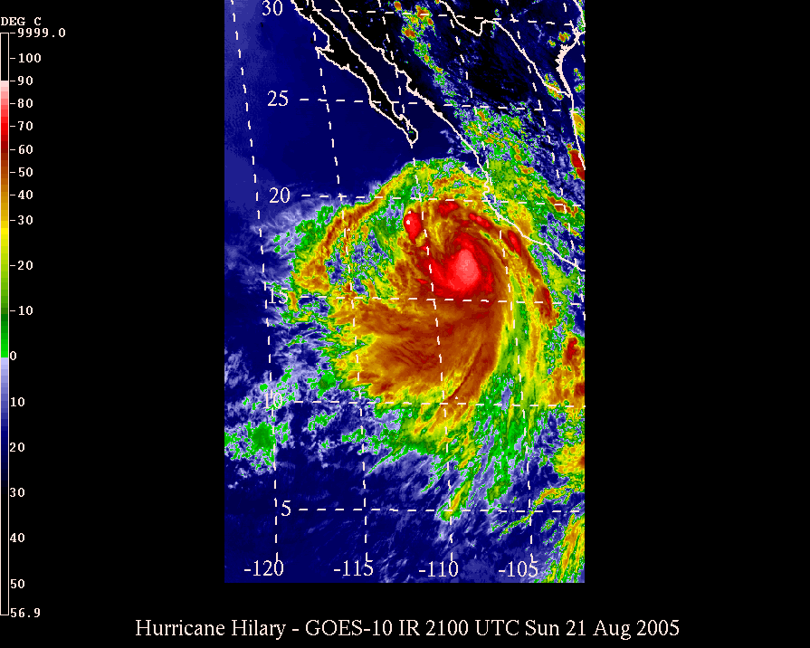
| 010 | 010 | None | None | 2100 Sun
Aug 21, 2005 |
Hurricane | EP | 107.8W | 16.6N | 20 | WNW | 979 | 75 | 90 |
|
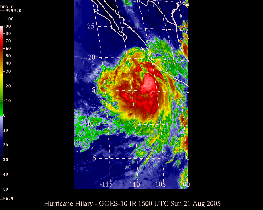
| 009 | 009 | None | None | 1500 Sun
Aug 21, 2005 |
Hurricane | EP | 106.1W | 15.6N | 13 | NW | 982 | 70 | 85 |
|
| 008 | 008 | None | None | 0900 Sun
Aug 21, 2005 |
Hurricane | EP | 105.3W | 14.6N | 6 | W | 982 | 70 | 85 |
|
| 007 | 007 | None | None | 0300 Sun
Aug 21, 2005 |
Hurricane | EP | 104.7W | 14.5N | 15 | W | 987 | 65 | 80 |
|
| 006 | 006 | None | None | 2100 Sat
Aug 20, 2005 |
Storm | EP | 103.2W | 14.4N | 12 | WNW | 994 | 55 | 65 |
|
| 005 | 005 | None | None | 1500 Sat
Aug 20, 2005 |
Storm | EP | 102.1W | 13.9N | 15 | W | 994 | 55 | 65 |
|
| 004 | 004 | None | None | 0900 Sat
Aug 20, 2005 |
Storm | EP | 100.6W | 13.7N | 17 | W | 1002 | 40 | 50 |
|
| 003 | 003 | None | None | 0300 Sat
Aug 20, 2005 |
Storm | EP | 98.9W | 13.7N | 12 | W | 1004 | 35 | 45 |
|
| 002 | 002 | None | None | 2100 Fri
Aug 19, 2005 |
Depression | EP | 97.7W | 13.6N | 21 | W | 1007 | 25 | 35 |
|
| 001 | 001 | None | None | 1500 Fri
Aug 19, 2005 |
Depression | EP | 95.6W | 13.2N | - | - | 1005 | 25 | 35 |
|
Back to main Tropical Weather page
This page is maintained voluntarily by the MKWC and the UHMET faculty, staff, and students.
It was last modified on: Wed, Jul 22 2020 - 2137 UTC
Send comments to: Ryan Lyman
|
|
|


