Maunakea Observatories Forecast
5 PM HST Friday 17 May (0300 UTC Saturday 18 May) 2024
|
Warning(s)
Fog, ice and high humidity
Chance for flurries/rain
Cloud Cover and Fog/Precipitation Forecast
There is a good chance for high humidity, fog, ice and/or light rain/flurries as thick widespread clouds pour in from the SW through the night.
Summary of Key Meteorological Variables
Summit temperatures will be near -0.5 C this evening and -1 C tomorrow morning. Winds will be from the west at 15-30 mph for today, easing to 10-20 mph through the night. Seeing and PW are expected to linger near or exceed 1 arcsecond and 4 mm, respectively, through the night.
|
 |
|
Discussion
While the tradewind inversion will begin to take shape near 8 thousand feet an influx of deep mid/upper-level moisture will likely contribute to more fog, ice high humidity and light rain/flurries mainly through the weekend. There is a good chance that this moisture will start to detrain into the surrounding air mass and/or shift out of the area, which will help reduce the risk for fog/precipitation for Monday and Tuesday night. Extensive daytime clouds are expected through the weekend, but should taper a bit for the early part of next week.
A band of broken to overcast thick clouds are set to pour in from the SW and pass mainly along the western skies over the next 2 nights. Nevertheless, there is a good chance that the eastern fringe of this band will cross over the summit, contributing to extensive cloud cover at the summit during this time. The upper portion of this band is expected to drift eastward on Sunday and will likely blanket summit skies for much of that night, then will break up in the area on Monday. While this could open up skies for that evening, more high clouds will fill in from the west and pass over/near the summit as that night progresses and for Tuesday night.
Precipitable water is expected to linger near or exceed 4 mm through the next 5 nights.
A mixture of boundary layer turbulence, instability and/or moisture will contribute to poor/bad seeing through at least Sunday night. There is a chance for a modest improvement in seeing as the atmosphere begins to dry for Monday night and could settle in around 0.5 arcseconds for Tuesday night.
Little change since the morning forecast...The rather impressive late-season cut-off low to the NW will remain quasi-stationary/steady before weakening and lifting off toward the NE late in the weekend. Fortunately, the bulk of the instability associated with the low will remain embedded within its associated convergence band over the northern/central portion of the state. This could allow subsidence to prevail to the east of the convergence band, which will help reshape an inversion near 8 thousand feet near the Big Island over the next several days. However, the low is expected to draw deep widespread moisture/clouds out of the tropics over the next 48 hours. This moisture will help fuel the convergence band to the west of the Big Island, but there is a very good chance the upper portion of this band (12 thousand feet and above) will scrape the Big Island over the next 2 nights. In addition, this portion is set to make a sweep through the Big Island as the low begins to fall apart between early Sunday morning and late Monday afternoon. This will probably contribute to a fairly saturated air mass above 12 thousand feet, resulting in more fog, extensive cloud cover, ice, high humidity and even light flurries/rain at the summit through the weekend. Convection may develop within the convergence band to the NW, but should pose little threat to the summit during that time. The risk for fog/precipitation at the summit should decrease dramatically once the remaining moisture detrains into the surrounding air mass and the inversion becomes well established by Tuesday morning.
|
|
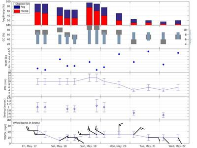
5 Day Forecast Summary (Graphical Trend)
| HST |
Cloud |
Fog/Precip |
Temp |
Wind |
Seeing |
PW |
| Cover (%) |
Height (km) |
Probability (%) |
(Celsius) |
(Dir/MPH) |
(Arcseconds) |
(mm) |
| Fri May 17 - 8 PM | 60-80 | 4-9 | 90 / 55 | -0.5 | W/15-30 | 0.7-1.3 | 8-12 |
| Sat May 18 - 2 AM | 60-80 | 4-8 | 90 / 50 | -1 | W/10-20 | 0.7-1.3 | 8-12 |
| 2 PM | 70-90 | 4-8 | 75 / 40 | 3 | ENE/0-10 | NaN | 8-12 |
| 8 PM | 50-70 | 4-8 | 65 / 30 | 0.5 | E/5-15 | 0.7-1.1 | 8-12 |
| Sun May 19 - 2 AM | 40-60 | 4-8 | 65 / 30 | 0.5 | ESE/5-15 | 0.7-1.1 | 8-12 |
| 2 PM | 80-100 | 4-10 | 95 / 75 | 2 | W/10-20 | NaN | 10-15 |
| 8 PM | 80-100 | 4-10 | 90 / 60 | -1 | WNW/10-20 | 0.7-1.5 | 10-15 |
| Mon May 20 - 2 AM | 60-80 | 4-9 | 75 / 40 | 0 | WNW/10-20 | 0.7-1.3 | 8-12 |
| 2 PM | 60-80 | 4-8 | 50 / 20 | 5 | N/10-20 | NaN | 6-10 |
| Tue May 21 - 2 AM | 20-40 | 6-9 | 25 / 10 | 2 | NE/10-20 | 0.5-0.8 | 3-5 |
| 2 PM | 40-60 | 5.5-9 | 20 / 10 | 6 | E/5-15 | NaN | 4-8 |
| Wed May 22 - 2 AM | 20-40 | 6-9 | 15 / 5 | 1 | SE/5-15 | 0.35-0.65 | 3-5 |
| 2 PM | 40-60 | 6-9 | 20 / 5 | 5.5 | SSE/5-15 | NaN | 4-8 |
|
Rise and Set times for the Sun and Moon
| Night (HST) |
Sun Set |
Twilight End |
Twilight Beg |
Sun Rise |
Moon Rise |
Moon Set |
Illumination (%) |
RA |
DEC |
| Sat May 18 - Sun May 19 |
19:02 |
20:13 |
4:24 |
5:35 |
N/A |
3:22 |
84 |
12 41.1 |
-4 42 |
| Sun May 19 - Mon May 20 |
19:02 |
20:14 |
4:23 |
5:35 |
N/A |
3:54 |
90 |
13 24.6 |
-10 21 |
| Mon May 20 - Tue May 21 |
19:03 |
20:14 |
4:23 |
5:34 |
N/A |
4:28 |
95 |
14 10.2 |
-15 43 |
| Tue May 21 - Wed May 22 |
19:03 |
20:15 |
4:22 |
5:34 |
17:26 |
5:07 |
99 |
14 59.0 |
-20 34 |
| Wed May 22 - Thu May 23 |
19:03 |
20:15 |
4:22 |
5:34 |
18:22 |
5:51 |
100 |
15 51.6 |
-24 36 |
|
Forecast Issued by: Ryan Lyman
Next update at 10 AM HST (2000 UTC) Monday 20 May 2024.
|
Additional Information
For public road conditions and snow report message please call (808) 935-6268.
This message is also available at the MKWC road conditions page.
NWS Hawaiian Islands Synoptic Discussion and Guidance
Honolulu National Weather Service Data and Products
|
